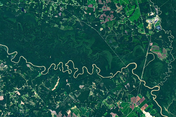
Congaree National Park in South Carolina is defined by the Congaree River’s floodplain, covering 80 percent of the park. NASA’s Landsat 9 imagery reveals the river’s impact on the landscape, creating diverse ecosystems based on flood frequency. The park contains one of the largest intact tracts of old-growth bottomland hardwood forests in the United States.
The Operational Land Imager on Landsat 9 captured the Congaree River winding through the forested plain, showcasing curving bands of green representing old channels, ridges, and swales formed by the river’s migration. Variations in elevation within these features influence flooding, resulting in distinct ecosystems with differing shades of green. The river’s flow across flat terrain encourages bends and meanders, causing erosion on the outside of curves and sediment deposition—including point bars—on the inside.
Over time, these processes can create U-shaped oxbow lakes. Weston Lake, 1.2 miles (1.9 kilometers) from the visitor center, is a relatively deep oxbow lake, differing from others in the park due to its lack of shallow clay and silt. Bates Old River, a 4-mile-long abandoned channel, is one of the longest oxbow lakes in South Carolina. Abandoned channels and oxbow lakes eventually become shallow wetlands, known as sloughs, where flood-tolerant cypress-tupelo forests thrive.
Despite logging attempts in the 1880s, frequent flooding, muddy conditions, and mosquitoes protected much of the floodplain forest. By the 1950s, conservationists recognized the rarity of these old-growth forests, leading to the area’s designation as a national monument in 1976 and a national park in 2003. The Congaree River overflows its banks several times a year, typically in winter and spring, but also after hurricanes and rainstorms. These floods deposit nutrient-rich silt, nourishing the forests and contributing to the growth of unusually large trees, including many “champion” trees.
Read the original coverage
💬 Comments
📜 Comment Policy