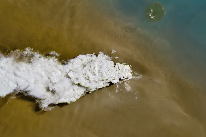
Anak Krakatau, a volcano located between Java and Sumatra, erupted in early September 2026, causing significant disruption to air travel and impacting air quality in Indonesia. The eruption, lasting over 24 hours, sent volcanic gas and ash high into the atmosphere.
On September 5, satellites captured images of the explosive activity. NASA’s Landsat 8 satellite’s Operational Land Imager (OLI) showed a white plume of volcanic gas billowing over a brown ash cloud. The Suomi NPP satellite’s Visible Infrared Imaging Radiometer Suite (VIIRS) captured a wider view of the dispersing volcanic material. By September 6, Indonesia’s meteorological agency reported ash reaching altitudes of up to 6,000 meters (20,000 feet) east of the volcano and 15,000 meters (50,000 feet) to the west.
The eruption prompted the temporary closure of eight airports on Java and Sumatra, disrupting nearly 3,000 flights, according to news reports. The Indonesian Humanitarian Coordination Platform (IHCP) reported ashfall affected populated areas, particularly Jakarta and West Java. Volcanic ash can pose health risks, irritating the respiratory tract, eyes, and skin, though the IHCP noted the air quality hazard differs from smoke produced by peatland fires in terms of particle characteristics, dispersal patterns, and protection measures.
By September 6, the continuous explosive eruption subsided, returning to a more typical pattern of Strombolian eruptions with intermittent spurts of ash. Airports resumed operation by September 8, but the volcano remained at the second-highest alert level, a status it has held since early July.
Read the original coverage
💬 Comments
📜 Comment Policy