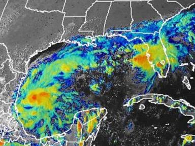
Tropical Storm Isaias formed in the Gulf of Mexico on Wednesday and is forecast to strengthen into a hurricane before making landfall on the U.S. Gulf Coast on Friday. The storm is expected to bring moderate to heavy rainfall, with 3 to 6 inches and up to 10 inches in some areas from southeastern Louisiana to the Florida Panhandle. It may become the first Atlantic hurricane of the 2026 season, which would be the latest first hurricane on record.
Isaias was located approximately 580 miles south of the Mississippi River and 285 miles west of Progreso, Mexico, with maximum sustained winds of 40 mph. The National Hurricane Center forecasts the storm will pass north of Mexico’s Yucatan Peninsula on Thursday before approaching the U.S. Gulf Coast. Hurricane watches are likely to be issued for portions of the northern Gulf Coast later Wednesday. Tropical storm-force winds extend outward up to 45 miles from the storm’s center.
Florida Governor Ron DeSantis declared a state of emergency for 25 Florida counties on Tuesday, citing the potential for severe weather impacts to the Panhandle and Big Bend region. The 2026 hurricane season ends November 30th. While the Atlantic has seen a relatively quiet season due to El Niño, activity in the Pacific has been above average. Isaias is the ninth named storm of the Atlantic season. The storm’s name, Isaias, replaced “Ike” on the Atlantic tropical cyclone list after Ike was retired in 2008.
Notably, “I”-named storms have a history of being retired due to their severity, including Ian (2022), Ida (2021), Irma (2017), and Irene (2011). Some longer-range forecast models suggest the storm’s moisture could reach the Ohio Valley and Northeast by next week.
Our reading is that despite a relatively quiet Atlantic season overall, Isaias represents a potential escalation of weather-related risk to the Gulf Coast. The article highlights the unusual timing of a potential first hurricane, and the fact that “I”-named storms are frequently retired suggests a history of significant impact. The varying emphasis across news outlets on specific details, like wind speed and location, indicates a developing story where the precise threat remains uncertain.
Read the original coverage
💬 Comments
📜 Comment Policy